Otto Zoberbier’s
My Journey through the Orient
translated into English from Werner Zoberbier’s German edition (version “WZ“) of his father Otto Zoberbier’s handwritten version (“²OZ“, the so-called “Zweitschrift”)
Translation drafted with the help of DeepL and GPT (UiO), proof-read by Kathinka Zoberbier and Stephan Guth
Annotated by Stephan Guth
Epilogue (in lieu of a foreword)
5 New Destination: Persia67
On the 19th of March, the time had come for me to start the journey to Persia with a comrade. I had still hoped to finally receive eagerly awaited mail from home after three months [lit., a quarter of a year], but apparently we had also left Baghdad again too quickly. Our transport consisted of four wagons loaded with telegraph material. We had our first breakdown while still in Baghdad. The iron rim of one wheel had come off and the arbadji[68] (coachman) had to go back and get a new wheel. But then we made good progress. The road was good, the horses fresh and rested, and we were able to set a sharp pace. My comrade, a telegraph operator who had probably never been on a horse before, preferred to sit on one of the wagons and let the horse follow on the reins. I, however, kept a firm grip on my horse and probably made a good riding horse out of him, which was not at all easy.
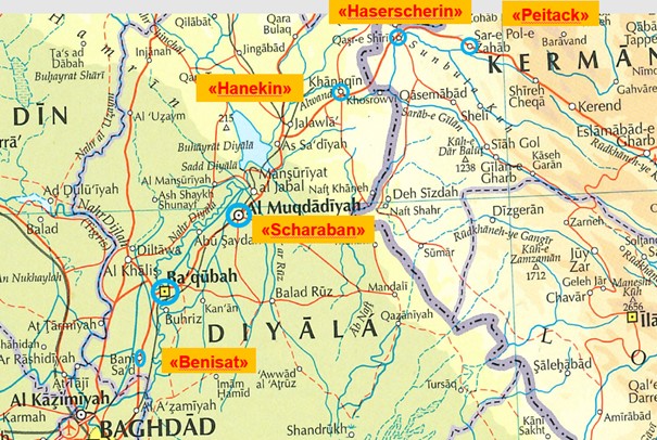
After only 33 kilometres we stopped in the village, Benisad,[68] and decided to spend the night here because we had lost a lot of time due to the wheel change in Baghdad. For a change <p7a> we had canned meat to go with the usual bread, scrambled eggs and tea. The next leg was also short. After a little over 30 kilometres, we reached Bakuba,[69] a beautiful oasis, splendidly situated on the Sapp,[70] a tributary of the Tigris. We felt as if we had been transported to paradise. We admired the beautiful town and took the time to stock up on the oranges produced here, which are particularly large and very sweet.
From now on, the road got worse and worse. We entered a flooded area. The wagons kept getting stuck and progress was slow. Some mules got tired and refused to pull any more, so we didn’t make the planned, relatively short, distance of 36 kilometres to Sharaban.[71] Again and again the wagons got stuck in the mud, so that we had to join forces to pull them out of the swamp one by one. I had ridden ahead of the caravan up to the mountains, while my comrade supervised the caravan from his wagon. There was lovely fresh grass along the way. I dismounted and let my roan feed on the lush grass. I looked down from the hill and wanted to wait here for the wagon train. My faithful gray horse was still grazing and suddenly lost sight of me, neighed loudly, raised his head and started trotting off to look for me. I called after him and he calmly came back to me in a wide arc. It was getting dark by the time as our wagons slowly approached, so we decided to spend the night in a Turkish police station in the mountains.
The next morning we soon reached Sharaban. We did not stay here long, but pressed on to reach our intended destination that day, because it was urgently necessary to finally have a day of rest. Our mules were visibly exhausted after the exertions of the last few days and needed rest and recuperation.
On the 6th day we reached the Turkish-Persian border town of Hanekin.[72] The German back area set up here was manned by a German expatriate who had never been a soldier before, but who had quickly been given a military rank and uniform. They needed suitably deployable people in Turkey who did not actually exist, and quickly promoted a local German to the rank of sergeant.
Now the adventure really began. If we had had bad roads so far, from now on the road from Hanekin to [K]asersherin[6] in Persia became even worse. It could no longer be called a road. Maybe the road could have been used without any problems by a convoy of pack animals, but it was practically impassable for our wagons. From Hanekin, we went straight into the mountains that formed the border to Persia. A <p7b> castle built as a military station by the Turks guarded the border. From here it was more or less hopeless to continue with our wagons. Sometimes the path was so steep that the drawbar of the wagons stuck out above the heads of the mules, and we could only overcome the steep slopes by harnessing mules from other wagons. Then we went downhill again, where water and mud had formed deep puddles in which the wagons got stuck. Pulling them out was as tedious as pulling the wagons up the hill, only considerably dirtier. Downhill, the coachmen drove as fast as the mules could run, and it turned out as I feared. A wheel broke on one of the carts. We didn’t have any spare wheels, so the load had to be distributed among the other three wagons. We continued with only three wagons. But it wasn’t long before the first wagon got stuck again. Night had fallen and it was impossible to move on. We now had to spend the night in the open, but we were so exhausted that we slept wonderfully well. It wasn’t till afterwards that we learnt how unsafe the area was. The Lurs,[7] who live in this region, are considered to be dangerous.
When we woke up, we were surrounded by a number of people, who were quite friendly however. For a baksheesh[8] (tip) they helped us part of the way over the almost insurmountable obstacles. Yet no sooner had we overcome one than we encountered the next. In the end, I had no choice but to ride ahead to Hasershirin[9] to get help at the back area. After a 45-minute ride, I was able to explain the situation to the stage officer in charge. With 23 donkeys we then went back to our convoy, and with this help our transport comfortably reached [K]asersherin around noon. We were safe.
Now we had reached Persia. My comrade, with whom I had come from Baghdad, reported sick and was to return to Baghdad with the next caravan. I had a day’s rest. There wasn’t much to see in the village. And just one day later we had to hand in our luggage again at the back area, ready packed for the onward journey.
On 26 March 1916 at 7 a.m. the transport was to leave for [K]erent.[10] When I and another comrade reported to the meeting point as ordered, we were told that the caravan had already been on the road for two hours. The fact that we were late was not a problem, however, as the way was easy to find. We only had to follow the telegraph poles. My comrade, a 12th Hussar, and I trotted off along the main road. We passed small stalls where you could drink tea and have a snack. After five hours, we finally met up with our caravan. Together we continued to the next back area in Peitack.[11] Here I had to report to the officer in charge.
<p8a> The back area was led by a lieutenant who had been employed as an engineer in the construction of the Baghdad Railway before the war. I was to help him as his right-hand man, while my comrade, the hussar, moved on towards [K]erent. This is where I now settled down. –
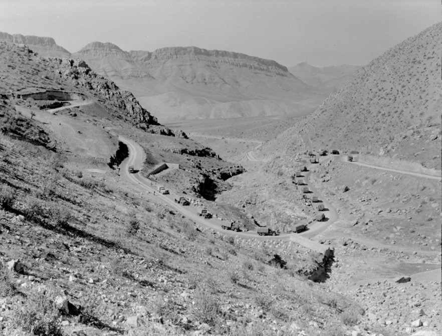
Peitack lies at the foot of the Peitack Pass[1] [Fig. 20], surrounded by high mountains and only accessible from the west through an open valley. This is where the caravan route from Baghdad via [K]erent, Hamada[2] to Tehran passes. The communication zone in Peitack was my new place of work from now on, and my new job could be called fairly quiet, or even very quiet. The caravans arrived from Baghdad, spent the night here, and moved on to the front at [K]erent the next morning. Mostly the caravans were accompanied by Austrian comrades who had escaped from Russian captivity and were temporarily on duty here.[3]
One of them was Heinrich Nitsche, a baker and confectioner from Böhmisch-Kamnitz[4] on the Silesian border. He became our cook, and from now on had to look after our physical well-being. He was obviously a brave man, for he was awarded the great Austrian medal for bravery, which he told us he received in the following way: With his regiment he was deployed on the Serbian front. One day, when it was very quiet on the base, he took the opportunity to go looking for spirits in the nearby village behind the front. He did so successfully. When things got lively again at the front, he quickly packed his treasures into a pram and chased forward. He had not yet reached the base when he ran into a colonel and his adjutant. “What have you got in there, son?” asked the colonel. “Ammunition, sir.” – “That’s a good boy. What is your name, my son?” – “Heinrich Nitsche.” Then the adjutant had to write down his name, and he received the big medal for bravery.
Heinrich had to have his daily ration of raki.[5] Without it he was sick and had malaria.[6] – We had established a very extensive depot here. Every day the fouriers[7] from the units at the front came over the pass to get their rations, mostly flour, rice and tea. Meat was only given out in the form of live mutton or goat. – I had plenty to do, but I still had a few hours left to go for a rides and explore the surroundings. There were supposed to be ibex[8] in the mountains. So I stalked through the area to hunt some, but without any success. There was no other game to be seen either.
In the meantime April had come. At last my first mail arrived, the Christmas mail. The cake was hard and mouldy. Nevertheless, I was happy to receive a sign of life from home. We had settled in well and felt <p8b> happy. The climate was pleasant, not warmer than 30 degrees. We could have lived a long time like this if the Russians had not advanced through Persia towards Baghdad.[9] The Turkish pass garrison consisted only of an infantry regiment, with a battery of artillery in support. A Persian band of tribal horsemen, commanded by Swedish officers,[10] fled before the Russians and placed themselves under the command of the German army. The Persian horsemen were not very brave; they gladly took the pay, but that did not increase their courage. In Baghdad they were all dismissed. The Swedish officers were transferred to the German units.
On [1]6[11] May 1916, we cleared our depot after the last Turkish formation had passed us. The troops were given as much of the food as they could carry, and the rest was left with the inhabitants, who almost fought over the supplies. When everything was cleared, we started our retreat. The next back area in [K]asersherin had already been abandoned by the Germans. We spent the night there, and went back to Hamekin the next day, where the new front had been established. This was then held for a long time after that.
We had the order to retreat as far as Bakuba. Two months ago, when we came along this road in the other direction, we were still wading through mud. Now, in over 50 degree heat, we were travelling over parched and dusty roads. The heat became torture, and it was difficult to get water, and I felt the first attacks of malaria.
In Bakuba, this beautiful oasis, the suffering was not yet over. The Turks provided us with a han (hostel)[12] 3 kilometres outside the city, right next to the desert. The han itself was a small fortress with a large gate, the inside consisting only of rooms with four bare walls for the animals, and outside there were only niches without doors for the people. The alcoves were protected with blankets against the strong rays of the sun. The heat was unbearable. Add to that a fever and a thirst that could not be quenched. How gladly would I have payed a mark for a glass of cool water.
I kept getting bouts of malaria. I reported sick to the captain of the back area and asked to be transferred to Baghdad. The captain agreed, and I was to accompany the next caravan there. The convoy was put together, everything was listed, but the captain’s signature was missing. The caravan was already leaving, but I still had to ride in the opposite direction to the town to get the captain’s signature. He had gone for a walk and <p9a> forgotten all about me. After at least an hour he finally came.
Because it was too hot during the day, we only marched at night. The caravan was now more than two hours ahead. And it was dark. In oriental nights you can see the stars, as there are no clouds in the sky between April and October, because of the dryness. Despite the darkness the path could not be missed, I only had to follow the telegraph poles. I trotted a little more briskly to catch up with the caravan quickly. I had hardly left the town when a stray horse joined me and trotted merrily along beside me. I had been riding for an hour and a half when I came to an empty ditch. Suddenly there was no more path, no more telegraph poles. I dismounted to look for wagon tracks. The ownerless horse had disappeared again. I searched left and right for the road, my horse on the reins. What they call a road here is often messed up in the rainy season between October and April,[13] and people then try to find another path beside the road. As a result, the road becomes wider and wider.
I didn’t know what to do in the dark and wanted to wait out the day here in the open. I was only wearing my khaki uniform. My luggage was with the caravan. I loosened my horse’s saddle and lay down on the ground. It was getting bitterly cold and I was soon freezing miserably. I got up again, tightened my horse’s saddle and, keeping the horse on the reins, walked back in the direction from which I had come, hoping to find the right path again. And I was lucky. After not too long, I found the road again and could now ride at a brisk trot towards Baghdad. I hoped to encounter the caravan before it reached Baghdad. Around two o’clock in the night I rode through Benisat, and I had now covered half the distance to Baghdad. I assumed that the caravan had already moved on, because I couldn’t imagine that it would break for the night after only 33 kilometres and then reach Baghdad by morning. I rode on. At sunrise I saw the flood area outside Baghdad. The Tigris was in flood and had overflowed its banks. The water was only ¾ m deep and it was possible to ride through the water to the city. I had made the 66 kilometres. At the back area I hoped to find my caravan, but nobody knew anything about it. The sergeant on duty, a Palestine German,[14] was not worried. He knew the local conditions. He just advised me to get some rest, because the caravan was bound to come.
I rode to the back area accommodation, which I already knew, put my horse in the stable and took a bath, which was very necessary, had breakfast, and finally went to sleep.
4 Baghdad ◄ ► 6 Back in Baghdad
Notes
[68] I.e., Turkish arabacı (cf. above, note 96).
[1] Cf. preceding note. The pass has an entry in its own right in the Fārsi Wikipedia, https://fa.wikipedia.org/wiki/گردنه_پاطاق (as of April 20, 2024) – thank you, Samad Alavi, for alerting me to this.
[2] WZ “Hamada”, ²OZ “Hammada”: seems to be Hamedān, on the road from Kerende-e Gharb between Kermānshāh and Ṭehrān.
[3] Cf. above, at note 80.
[4] Today Česká Kamenice in northern Czechia, on the border with Saxonia (located at a distance of only 22 km from Dresden). https://en.wikipedia.org/wiki/Česká_Kamenice (as of March 16, 2024).
[5] I.e., rakı, “an alcoholic beverage made of twice-distilled grape pomace and flavored with aniseed. It is the national drink of Turkey. It is popular in many Mediterranean countries and is often served as an apéritif or with seafood or meze. It is comparable to several other anise-flavored liqueurs such as pastis, ouzo, sambuca, arak and aguardiente. The alcoholic content of raki must be at least 40%” – https://en.wikipedia.org/wiki/Rakı (as of March 16, 2024). – Cf. also below, p. 246 (with note 202) where the author (wrongly) explains rakı is as “rice liquor”.
[6] This sounds as if the effects of malaria could somehow be contained by drinking alcohol, a belief that seems to be quite widespread in Africa until these days, cf., e.g., this report: https://www.n-tv.de/panorama/Kenianer-behandeln-Krankheiten-mit-Alkohol-article14977031.html (last accessed April 3, 2024). – I was unable to find other information on this “treatment” of the disease in other places or at other times.
[7] A “fourier” (in German also spelt “Furier”) is a person who is responsible of logistics, mostly in a military context (borrowed from French fourrier “dto.”, based on French fourrage “forage, food”).
[8] German Steinböcke (²OZ, WZ).
[9] The events Zoberbier is alluding to here can probably be seen in light of what is briefly described for early 1916 in the English Wikipedia entry on the “Persian Campaign”: “In January 1916, [Russian General Nikolai] Baratov’s forces drove off the Turks and Persian tribesmen and occupied Hamedan. They proceeded to capture Kermanshah on February 26, and Kharind [i.e., Kerend, see above, note 125] on March 12. […] [T]he Russians advanced and defeated the gendarmes, who then retreated to Qasr-i-Shirin and managed to hold the region until May 1916, when it was captured by the Russians.” “By the middle of May, Baratov had reached the Ottoman frontier, 150 miles from Baghdad” – https://en.wikipedia.org/wiki/Persian_campaign_(World_War_I)#1916 (as of April 3, 2024).
[10] The background for this detail may be the following: There was a small group of Swedish military officers who had volunteered to serve in Persia and were therefore deployed there between 1911 and 1916. “The goal was to quell regional uprisings and modernize the Persian army, but as a result of pressure from Russia and the United Kingdom, Sweden decided to call back most of their officers during World War I. [… This happened after the Swedes had] help[ed] the Persians and engaged in numerous battles with the Allies […]. After Sweden decided to call back their soldiers, five Swedes decided to stay serving as volunteers under German leadership […]” – https://en.wikipedia.org/wiki/Swedish_volunteers_in_Persia (as of April 3, 2024).
[11] ²OZ 43 “Am 6ten Mai”, WZ 8b “Am 16. Mai”. Difficult to decide which version is to be preferred.
[12] See above, note 75.
[13] The climate data given by Zoberbier here match very well the meteorological data provided in https://en.wikipedia.org/wiki/Baghdad for Baghdad in recent decades (1991-2020), based on climate observations made, among others, by the World Meteorological Organization (WMO) (entry last accessed on April 6, 2024):
| Month | Jan | Feb | Mar | Apr | May | Jun | Jul | Aug | Sep | Oct | Nov | Dec |
| Record high °C | 24.8 | 28.2 | 36.6 | 42.0 | 46.7 | 49.6 | 51.8 | 50.0 | 47.7 | 40.2 | 35.6 | 25.3 |
| Mean daily maximum °C | 16.2 | 19.3 | 24.5 | 30.5 | 37.1 | 42.2 | 44.7 | 44.5 | 40.3 | 34.0 | 23.9 | 18.0 |
| Daily mean °C | 10.0 | 12.8 | 17.5 | 23.4 | 29.5 | 33.4 | 35.8 | 35.3 | 31.2 | 25.1 | 16.5 | 11.7 |
| Mean daily minimum °C | 4.7 | 6.5 | 10.5 | 15.7 | 21.1 | 24.9 | 26.9 | 26.2 | 22.2 | 17.2 | 10.2 | 6.0 |
| Record low °C | −11.0 | −10.0 | −5.5 | −0.6 | 8.3 | 14.6 | 22.4 | 20.6 | 15.3 | 6.2 | −1.5 | −8.7 |
| Average precipitation mm | 24.6 | 16.6 | 15.7 | 16.2 | 3.3 | 0 | 0 | 0 | 0.1 | 7.6 | 23.6 | 17.0 |
| Average precipitation days | 5 | 5 | 6 | 4 | 2 | 0 | 0 | 0 | 0 | 1 | 5 | 6 |
| Average relative humidity (%) | 69.1 | 58.9 | 48.7 | 41.1 | 31.4 | 24.4 | 23.8 | 25.7 | 30.9 | 41.6 | 57.9 | 68.0 |
[14] Cf. above, notes 95 and 106, and below, note 195.
[1] Here spelt with final -d (no correspondence in ²OZ), on later occasions with -t (in these cases, ²OZ has “Be-ni-sat”. The village in question seems to be Banī Saʿd, located, roughly, halfway between Baghdad and Baʿqūba.
[2] I.e., Baʿqūba, capital of the Diyālà province, located on the Diyālà river.
[3] Unanimously spelt “Sapp” in ²OZ and WZ. Given Baʿqūba’s location, this “Sapp” must be the Diyālà or a tributary. However, nothing that would sound like “Sapp” is mentioned as alternative name of the river (besides Kurdish Sîrwan or Persian Sīrvān) in any of the references I was able to consult. – Could Zoberbier’s “Sapp” be the Arabic Zāb? There are the Great (or Upper) Zāb and the Little (or Lower) Zāb, but both are much further to the northwest…
[4] Variably spelt Cha-ra-ban and Scha-ra-ban in ²OZ. – Sharabān (< Persian shahrabān, from old Iranian xšathrapavan-, literally “guardian of the realm,” from xšathra‑ “realm, province” + pavan‑ “guardian”, cf. Greek loanword satrapēs “satrap, governor, governorate”) is an alternative (older) name of what on contemporary maps usually appears as al-Miqdādiyya (or Muq…), a town situated 80 km northeast of Baghdad and 30 km northeast of Baʿqūba.
[5] I.e., Khānaqīn, a town in Irak on the Ḥelwān river, with a bridge that must go back to Sāsānian times. “At the Muslim conquest, a battle seems to have been fought at Khāniḳīn […]. Under Arab rule Khāniḳīn was a small town and an unpretentious station on the road from Baghdād to Khurāsān. Ibn al-Muʿtazz praises the wine of Khāniḳīn. According to Abū Dulaf, a naphtha well at Khāniḳīn yielded a considerable revenue to the state” – P. Schwarz, “Khāniḳīn”, in ²EI, http://dx.doi.org.ezproxy.uio.no/10.1163/1573-3912_islam_SIM_4190, first published online: 2012 (consulted 23 March 2024).
[6] Ambiguous spelling in ²OZ (Ha‑/Ka‑?), invariably (but wrongly) rendered as Ha- in WZ. The town in question is Qaṣr-e Shīrīn in Persian Kurdistān on the right bank of the Ḥulwānrūd. “Ḳaṣr-i S̲h̲īrīn was an important caravan station from the earliest times. The most important route through it is the very old road from Baghdād to the Iranian highlands […]. Ḳaṣr-i S̲h̲īrīn lies about half-way between the two stations of Khāniḳīn in the south-west and Sar-i-pul (in mediaeval times Ḥulwān, south of Sar-i-pul) in the east. […] The most remarkable feature of Ḳaṣr-i S̲h̲īrīn […] is the extensive system of ruins dating from the Sāsānian period in its vicinity. […] Ḳaṣr-i S̲h̲īrīn and the neighbourhood was the scene of the unhappy love-story of S̲h̲īrīn and the royal architect Farhād [i.e., Farhād wa-Shīrīn]” – M. Streck and J. Lassner, “Ḳaṣr-i S̲h̲īrīn”, in ²EI, http://dx.doi.org.ezproxy.uio.no/10.1163/1573-3912_islam_SIM_3999, first published online: 2012 (consulted 23 March 2024).
[7] (In Persian Lor, with o short), “an Iranian people living in the mountains in southwestern Persia. […] the principal link among the four branches of the Lurs (Mamāsanī, Kūhgīlūʾī, Bakhtiyārī and Lurs proper) is that of language. The special character of the Lur dialects suggests that the country was Iranicised from Persia and not from Media. […] The main groups of Lur are: Tarhān, Dilfān, Silsila […] and Bālā-girīwa. The tribes of the last group are the Lurs par excellence and have important subdivisions: Dirīgwand, Sagwand etc. It is possible that the Dirīgwand are the real nucleus of the Lur race” – V. Minorsky, “Lur”, in ²EI, http://dx.doi.org.ezproxy.uio.no/10.1163/1573-3912_islam_COM_0587, first published online: 2012 (consulted online on 23 March 2024). – “Lurs are a mixture of aboriginal Iranian tribes, originating from Central Asia and the pre-Iranic tribes of western Iran […]. In accordance with geographical and archaeological matching, some historians argue that the Elamites were the Proto-Lurs, whose language became Iranian only in the Middle Ages” – https://en.wikipedia.org/wiki/Lurs (as of March 23, 2024).
[8] Arabic baqshīsh or bakhshīsh, from Turkish bahşiş, from Persian bakhshīsh “tip”, based on bakhshīdan “to give”, akin to Avestian bakhsh‑ – Rolland 2014, s.v.
[9] See above, note 121.
[10] ²OZ rather has (correct) initial K‑ than H‑ (which WZ has throughout). The location in question seems to be modern Kerend(-e Gharb), also known as Karand or Karīnd (Kurdish Kirin), a city in the Central District of Kermanshah province, Iran – https://en.wikipedia.org/wiki/Kerend-e_Gharb (as of March 23̈, 2024).
[11] I.e., Pāṭāq (also Pā-ye Ṭāq, https://en.wikipedia.org/wiki/Pataq, as of April 20, 2024), a village close to modern Sarpol-e Ẕahāb (located in the place of the ancient Ḥulwān, Greek χάλα), “situated near the entrance to the Paytak pass through the Zagros range, on the famous Khurāsān highway” – L. Lockhart, “Ḥulwān”, in ²EI, consulted online on 23 March 2024, http://dx.doi.org/10.1163/1573-3912_islam_SIM_2945, first published online: 2012. – In the German Wikipedia entry, Sarpol-e Ẕahāb is described as “Tor zum geschichts-trächtigen Paitak Pass, der über das Zāgros-Gebirge ins Iranische Binnenbecken führt” (gateway to the historic Paitak pass, which leads over Zāgros Mountains into the central Iranian bassin). The National Library of Australia holds a photography (of 1944) showing “The famous Paitak Pass that leads from the Plains to the plateau heights” and which seems to have played a role also in WW II – https://nla.gov.au/nla.obj-159651855/view (as of March 27, 2024). On another Australian website (https://www.awm.gov.au/collection/C304798), the etymology “Pai-Taqa” is given in parentheses, and the pass said to be “also known as the Gates of Zagros, from Kasr-i-Shirin along the Persian Road towards Hamadan”.
