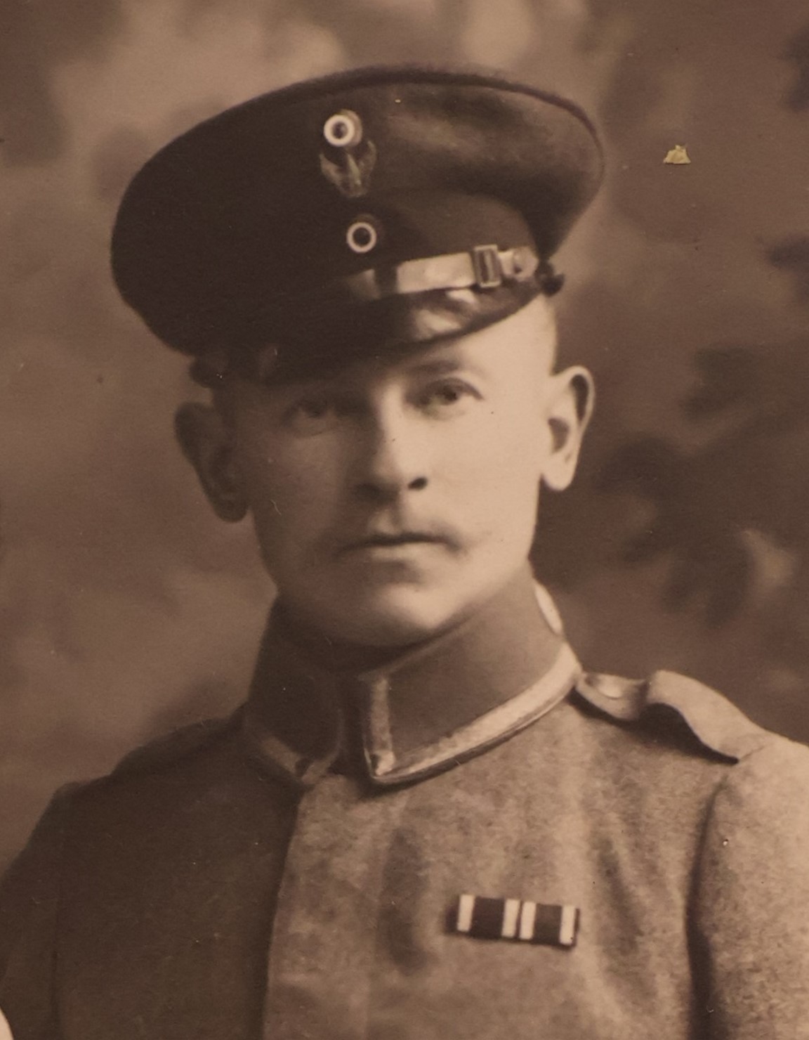
Otto Zoberbier’s
My Journey through the Orient
translated into English from Werner Zoberbier’s German edition (version “WZ“) of his father Otto Zoberbier’s handwritten version (“²OZ“, the so-called “Zweitschrift”)
Translation drafted with the help of DeepL and GPT (UiO), proof-read by Kathinka Zoberbier and Stephan Guth
Annotated by Stephan Guth
Epilogue (in lieu of a foreword)
8 Retreat
In this way time passed quickly. I spent Christmas with my comrades in Baghdad and received the gifts of love for Redwanje there. New Year was over and everyday life resumed. A transport had just been dispatched and I was about to collect the due payment the next day, when in the evening the call came from Baghdad to evacuate Redwanje immediately and start the retreat.[1]
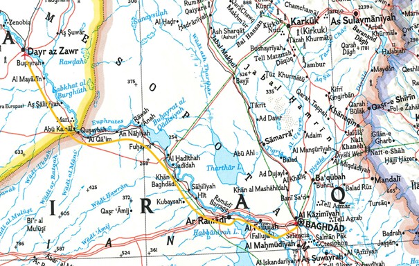
We were caught completely by surprise. Just before, a motor shakhtoor[2] (motor boat) with a crew of four had arrived. We were ordered to go upstream on the Euphrates to Feludja[3] and intercept another money transport there. We were at a loss. We had just two horses and no means of transport, but we had four sailors and a motorised shakhtoor without fuel. We had to leave the shakhtoor behind in Redwanje. We drummed up our Arabs, who brought all the donkeys at their disposal. They loaded up our belongings onto the boats and brought us to Feludja in two days. Now we were expected to pay but because of our hasty departure we were almost out of money. We agreed with the sheikh that his troop would return, and that he and his son would accompany us to Feludja to receive his payment there. There we were supposed to take over a money transport.
In Feludja we had to wait another two days before the promised money transport finally arrived. The donkeys were now gone again, the shakhtoor with which the money transport had come had no engine and was only suitable for travelling downstream. Again we were left without a means of transport to ferry carry the cash transport back. We were already loading the money boxes back onto the shakhtoor to be pulled upstream by another group of Arabs when a caravan of camels sent after us arrived. The shakhtoor was unloaded again, and the money boxes were now loaded onto the camels. But there were enough camels only for transporting the money. There was no more room for us and our own things. We couldn’t expect the sailors to walk all the way to Romadi,[4] our next destination, so we hired three riding horses and two teams to carry everyone and everything. Even the sailors were now mounted.
We reached Romadi, a Turkish back area, the next day and were able to send back the horses and carts we had hired in Feludja. After four sailors had joined us in Redwanje, we were now joined by another officer and three more men in Feludja. Our crew strength from <p13a> now consisted of two officers and eight men. In addition, there were the two Arabs from Redwanje who still hadn’t received their money for the donkey transport. We did get horses and pack animals here for the onward transport, but we could not pay our sheikh and his son despite all the money in the money boxes. So they joined us on our way to Hit,[5] where there was a German back area and where they were certain to get their money. The whole thing began to seem strange to them, and they became suspicious. So far they had served us well, and had even looked after us, although our lieutenant treated them quite roughly and even threatened to beat them. So the next night, when all but the sentries were asleep, they stole the lieutenant’s and his servant’s rifles and disappeared, never to be seen again. Apparently, the two carbines were worth more to them than the effort and work they had expended.
Our way now led us up the Euphrates on the old road to Aleppo, which I already knew. It led via Hit and Ana[6] to Deressor,[7] where there was again a German back area to which we handed over the transport. Here we could finally relax after the exhausting and exciting days. A German comrade, the son of the court photographer from Metz, was also buried in the local cemetery. He had been commanded along with us as a photographer to the von der Goltz staff.[8] In Tarsus we had celebrated the Emperor’s birthday[9] together. We were told that he had pitched a tent on his shakhtoor to protect himself from the sun and heat, and that when a storm came and the shakhtoor capsized, he tried to save his precious photographic equipment from his tent and then drowned with the shachtur.
The back area in Deressor assembled a large caravan of 96 camels. The four sailors left us here to join their unit upriver in Sharablus.[10] Our lieutenant and five men, including myself, were assigned to accompany the transport. Our destination was Mosul, which is again on the Tigris. On our ride through the desert, we could only orient ourselves by means of a compass. Not a tree or bush was to be seen. The first night we spent the night in the desert, we had not found a watering hole. The poor horses, although used to the climate, were thirsty, but had to bear without water for two days. The camels didn’t mind, they could live three to four days without water. On the second day we reached the Chabur,[11] a tributary of the Euphrates, and here we rested for a whole day. That was bitterly needed. When we wanted to leave the next day the camel drivers came running excitedly, shouting that a camel had run away. Now <p13b> we had to find the camel again. This caused us to lose another day.
From now on we stayed a day at each waterhole we encountered. The camels were freed from their burden and could eat from the fresh grass, because in March and April the desert becomes a lush meadow. The camels liked the thorny thistles best. We continued in a north-easterly direction, through the part of the desert area where the Armenians had been driven to and where they had met their death.[12] On the third day, I had another bout of malaria, so severe that I could hardly keep myself in the saddle. It was the last I was to experience in the Orient. In the evening we came across a kind of watering hole, but the water was so dirty that it didn’t even seem suitable for washing. We boiled it, but the tea and rice made with the water were unusable. Often the waterholes were just deeply dug holes covered in disgusting green mud. At other times we found crystal-clear water which, however, smelled of petroleum or saltpeter,[13] and we could only drink the tea we had brewed with it after we had sweetened it heavily.
The Bedouins were peaceful, asking us where we came from and where we were heading. We stayed there one night and moved on the next morning.
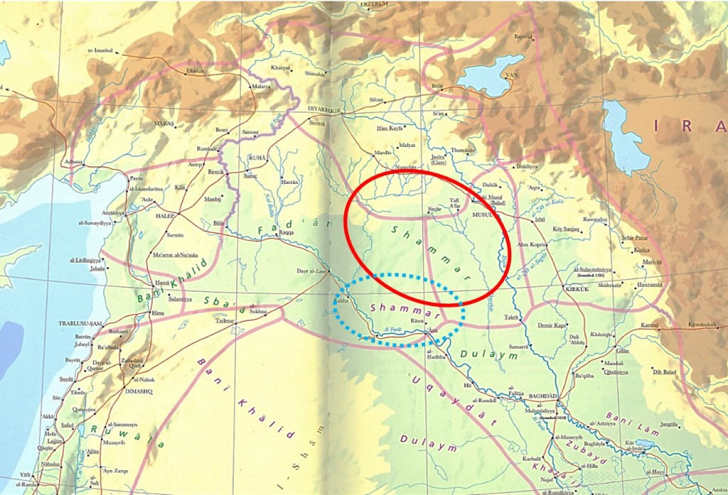
For eight days we rode like this through the desert without seeing a soul. Then suddenly everything was black with tents, camels and other animals grazing around the tents. It was the Chamar tribe[14] that stayed here on their treck from waterhole to waterhole [cf. Fig. 21].
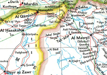
To the north-east, we saw the snow-covered peaks of the Sin[d]jar[15] Mountains on the horizon. We now met Bedouins regularly, who talked to our camel drivers and drank tea with them. They were curious because apparently we were the first Europeans they had ever seen in their lives. They were peaceful, yet we were still cautious and posted guards so we wouldn’t be ambushed.
We had now been in the desert for ten days when we finally came to a town again: Telhafa.[16] We wanted to rest here for a day. We were guests of the sheikh, who served us rice and mutton in true Arabic style. Here we had to demonstrate what we had learned in terms of customs, manners and language after one year in Arabia. Everyone sat on the ground in a circle around , in the middle the big copper bowl containing the rice and mutton. They did not use forks and spoons. We grabbed the food with our hands like the Arabs and enjoyed it. The greatest wish of our hosts was to be given a German rifle, which we unfortunately could not fulfil. Some German soldiers however are rumoured to have succumbed to temptation and sold their rifle for good <p14a> money. They then had to pay a high price too, because they were severely punished if they were found out.
On the 12th day we finally reached Mosul. Mosul is on the banks of the Tigris. We called it the city of death because it was surrounded by graveyards. There was a desert to the south and west, and to the north you could see the Caucasus with its snow-covered peaks.[17] And it was hot again, 70 to 80 degrees in the sun. The stay became hell in this heat. It was impossible to handle or just touch stones or iron parts lying in the sun. In the evening, we wanted to swim in the Tigris to cool down a bit, but we couldn’t do that either because the sand and stones on the shore were too hot. And although the Tigris had a strong current, its water was still hot. – We had to bury a good comrade, a Württemberg dragoon, a Swabian, here. He couldn’t withstand the climate. He found his final resting place in the garden of the German consulate, next to a German pilot captain who had crashed here.
On the eastern side of the Tigris lies the ruined city of Nineveh,[18] which is already mentioned in the Bible. On top of a hill you can see the mosque where the coffin with the bones of the Prophet Jonah is buried.[19] After taking off our shoes, we were allowed to visit the mosque and take a closer look at the sarcophagus. One evening we witnessed a total lunar eclipse, and as the moon darkened the Arabs started shooting like mad to drive away the supposed evil spirits.
On the Euphrates
New Job: Caravan Guide
Notes on ch. 8
[1] Since December 1916, the British under General Maude had been advancing towards Baghdad along the Tigris river, “forcing the Ottoman army [under Khalīl Pasha] out of a number of fortified positions along the way. […] By early March, the British were at the outskirts of Baghdad […]. Khalil Pasha retreated in disarray out of the city. On 11 March 1917, the British entered Baghdad” – https://en.wikipedia.org/wiki/Mesopotamian_campaign#1917 (as of April 7, 2024).
[2] See above, note 148.
[3] See above, note 111.
[4] See above, note 110. – At the time, al-Ramādī obviously was still under Ottoman control. “Ramadi was twice fought over during the Mesopotamian Campaign of World War I. It was held initially by the forces of the Ottoman Empire, which garrisoned it in March 1917 after losing control of Fallujah to the east. The British Army’s Lieutenant General Frederick Stanley Maude sought to drive out the garrison in July 1917 but faced severe difficulties due to exceptional heat during both day and night. […] Maude tried again during a cooler period in September 1917. This time the attacking force, led by Major General H.T. Brookings, was better organised and the British force was able to cope with the temperatures […] and […] to take control of Ramadi” – https://en.wikipedia.org/wiki/Ramadi.
[5] See above, note 107. – After British troops had captured Ramādī in September 1917, the army advanced again on March 9, 1918, occupying the town of Hit “in a bloodless victory, the Ottoman forces evacuating without a shot being fired. The next objective along the Euphrates was the town of Khān al Baghdādī [see above, note 109]. [… A strong mobile force] sent on a wide flanking march around Khan Baghdadi, and dug in behind the Ottoman positions. […] The entire force of about 5000 men [Ottomans] were taken prisoner. [… Shortly later, the British also took] the settlement of ʿĀna [see above, note 103]. Here was the main Ottoman supply base, which was now captured along with some high-ranking German officers attached to the Ottoman Army. The main Ottoman force under the command of Mustafa Kemal Pasha however had managed to successfully retreat further north and avoid capture. / This was the last attack on the Euphrates Front” – https://en.wikipedia.org/wiki/Action_of_Khan_Baghdadi (as of March 26, 2024).
[6] See preceding note and above, note 103.
[7] ²OZ 70 “Der-es-sor”, i.e., Deir al-Zor, see above, note 101 (²OZ “Der es Soor”, WZ “Dar es Sor”).
[8] See “Editor’s introduction” and note 46.
[9] See above, note 81.
[10] ²OZ “Cherablus”, WZ “Scharablus”, i.e., Jarābulus (dial. Arabic Jrāblos, Turkish Cerablus or Carablus, English spelling mostly Jarabulus), a city “on the western bank of the Euphrates […], [today] just south of the Syria–Turkey border and the Turkish town of Karkamış”, “administratively belonging to Aleppo Governorate. […] Being on the southern side of the Istanbul-Baghdad railway, Jarabulus became a border town with Turkey based on the Treaty of Lausanne in the aftermath of World War I” – https://en.wikipedia.org/wiki/Jarabulus (as of April 1, 2024). In Zoberbier’s time, Jarābulus was of course still part of the Ottoman Empire. In 1913, the “Djerablus” railway station had been built between Jarābulus and Karkamış under German planning. At the same time, a road bridge was built over the Euphrates south of the railway bridge (cf. pictures taken in Dec. 1914/Jan. 1915, in Veltzke 2014, 299). In 1923, the area came under the French mandate and the course of the Baghdad railway was defined as the border, so that Jarabulus fell to Syria. The railway station became a no-man’s land – https://de.wikipedia.org/wiki/Dscharābulus (as of April 1, 2024).
[11] I.e., one of the two “Khābūr” rivers, “the largest perennial tributary to the Euphrates in Syria [another Khābūr is a tributary of the Tigris in northern Iraq]. Although the Khabur originates in Turkey, the karstic springs around Rās al-ʿAyn are the river’s main source of water. Several important wadis join the Khabur north of al-Ḥasakah, together creating what is known as the Khābūr Triangle, or Upper Khābūr area. From north to south, annual rainfall in the Khābūr basin decreases from over 400 mm to less than 200 mm. This has made the river a vital water source for agriculture throughout history. The Khābūr joins the Euphrates near the town of Buṣayrah” – https://en.wikipedia.org/wiki/Khabur_(Euphrates) (as of March 25, 2024).
[12] Cf. above, note 100.
[13] Cf. above, note 100.
[14] I.e., the Shammar, “a tribal […] confederation, descended from the Ṭayy, which migrated into the northern Arabian Peninsula from Yemen in the second century. It is the largest branch of the Ṭayy, and one of the largest and most influential Arab tribes. The historical and traditional seat of the tribe’s leadership is in the city of Ḥāʾil in what was the Emirate of Jabal Shammar in what is now Saudi Arabia. In its ‘golden age’, around 1850, the Shammar ruled much of central and northern Arabia from Riyadh to the frontiers of Syria and the vast area of Upper Mesopotamia […]. / One of the early famous figures from the tribe was the legendary Ḥātim al-Ṭāʾī (Hatim of Tayy; died 578), a Christian Arab renowned for generosity and hospitality who figured in the One Thousand and One Nights. […] / […] some sections of Ṭayy, and most of the Ghassanids and Lakhmids, were present in Mesopotamia and the Levant prior to Muḥammad’s preaching of Islam in the early 7th century. […] / […] the Ṭayy invaded […] northern Arabia in their exodus from Yemen in 115 CE. […] The Ṭayy became nomadic camel-herders and horse-breeders in northern Najd for centuries. Because of their strength and blood relations with the Yemenite dynasties that came to rule Syria (the Ghassānids) and Iraq (the Lakhmids), the Ṭayy expanded north into Iraq all the way to the capital at the time, al-Ḥīrah. The area of the two mountains subsequently came to be known as Jabal Shammar (Shammar’s Mountain) from the 14th century, the first time that the Shammar as a tribe were noted in literature. […] / The Shammar is Iraq’s largest Arab tribe […], with [today] more than 1.5 million members. […]” – https://en.wikipedia.org/wiki/Shammar (as of March 25, 2024; most transliteration signs added by myself, S.G.).
[15] WZ 13b has “Sinajar”, an obvious misreading of ²OZ 72 which has “Sindjar” (where the upper part of the d is rather short).
[16] ²OZ 72: “Tel-Ha-Fa”, i.e., probably, Talʿafar / Tall ʿAfar (Turkish Telafer), “located 63 km west of Mosul, 52 km east of Sinjar […]. Its local inhabitants are exclusively Turkmen” – https://en.wikipedia.org/wiki/Tal_Afar (as of March 25, 2024). – Elsewhere, WZ spells the name of the town “Telhalief” (see below, p. 242 with note 186) or “Tehofa” (p. 243, n. 190).
[17] Does Zoberbier really mean the Caucasus? It would be at a distance of more than 800 km… Cf., however, below, p. 243 (with note 193), where the Caucasus is mentioned another time.
[18] Nineveh was an ancient Assyrian city, close to modern-day Mosul. ”It is located on the eastern bank of the Tigris River and was the capital and largest city of the Neo-Assyrian Empire, as well as the largest city in the world for several decades. Today, it is a common name for the half of Mosul that lies on the eastern bank of the Tigris […]. Its ruins lie across the river from the historical city center of Mosul. The two main tells, or mound-ruins, within the walls are Tell Kuyunjiq and Tell Nabī Yūnus, site of a shrine to Jonah [see next footnote]” – https://en.wikipedia.org/wiki/Nineveh (as of March 25, 2024).
[19] The “Al-Nabī Yūnus Mosque was a historic mosque located in Mosul, Iraq. It contained a tomb believed to be that of the Biblical prophet Jonah, known as Yūnus by Muslims. The alleged grave of the Prophet Yūnus was discovered […] during [the] reconstruction of the site as a congregational mosque in 1365. However, the mosque was also built over a demolished Assyrian Christian church that marked Jonah’s grave. […] The sarcophagus believed to be that of Jonah had a wooden zarih [i.e., ḍarīḥ, a lattice structure, in modern Arabic “tomb, sepulcher”] built around it. […] On 24 July 2014, the building was blown up by the Islamic State of Iraq and the Levant […]. They stated that ‘the mosque had become a place for apostasy, not prayer’ [the tomb of Jonah had been a popular pilgrimage site]. In March 2017, after ISIL was driven out, a system of tunnels about one kilometre long were found under the mosque. Although all moveable items had been removed, there were still Assyrian reliefs, structures and carvings along the walls” – https://en.wikipedia.org/wiki/Al-Nabi_Yunus_Mosque (as of April 6, 2024).
On the Euphrates
New Job: Caravan Guide
